Camel's Hump Lookout Site
US 1957, CA 111
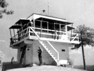
Camel's Hump Lookout - 1963
Lookout Details
| Registry Numbers | US 1957, CA 111 (view other lookout sites in United States, California) |
| Date Registered | April 1, 2020 |
| Nominated by | Brad Eells |
| Location |
Tahoe National Forest Nevada County, California |
| Coordinates |
N 39° 12.981' W 120° 51.073' (view using Google Maps) N 39° 12' 59" W 120° 51' 04" N 39.216355° W 120.851216° |
| Elevation | 3,548 ft (1,081 m) |
| Built | Circa 1939 |
| Removed | Unknown |
| Administered by | US Forest Service - Tahoe National Forest |
Description
Camel's Hump was constructed in 1938, a California Region 5 Plan BC-301 on an 8 foot enclosed timber tower.
Removal date is unknown, some ruins are remaining at the site.
Map
Change Basemap