Ashburnham Tower Site
US 2, MA 2
Lookout Details
| Registry Numbers | US 2, MA 2 (view other lookout sites in United States, Massachusetts) |
| Date Registered | May 9, 2008 |
| Nominated by | Henry Isenberg |
| Location |
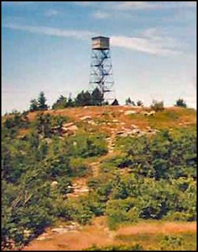
Mount Watatic Worcester County, Massachusetts |
| Coordinates |
N 42° 41.887' W 071° 53.640' (view using Google Maps) N 42° 41' 53" W 071° 53' 38" N 42.698110° W 071.894000° |
| Elevation | 1,590 ft (485 m) |
Description
In 1917, the original 48' tower with stairs was built and one mile of phone line was constructed to this tower. The tower was destroyed in the great hurricane of 1938. In 1939, a new steel Aermotor style tower was built by men of the CCC. In 1940, a new phone line was constructed down the south side of the mountain to Ashburnham. In 1941, a second phone line was constructed down the north side of the mountain to the town of Ashby. In 1950, the tower was again blown down and destroyed in a hurricane wind. In 1951, a new Aermotor MC-39 style tower was built and In 1960, a new cab was built. In 1970, the north side phone line was abandoned and the south side line was buried underground. This station was closed at the end of the 1979 fire season. The tower was removed and sold in 1996 to a Connecticut resident.
Map
Change Basemap