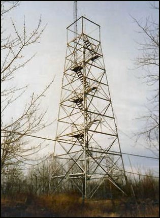
Brimfield Tower Site
US 3, MA 3

Lookout Details
| Registry Numbers | US 3, MA 3 (view other lookout sites in United States, Massachusetts) |
| Date Registered | May 9, 2008 |
| Nominated by | Henry Isenberg |
| Location |
Steerage Rock Hampden County, Massachusetts |
| Coordinates |
N 42° 08.983' W 072° 13.466' (view using Google Maps) N 42° 08' 59" W 072° 13' 28" N 42.149720° W 072.224440° |
| Elevation | 1,100 ft (335 m) |
Description
In 1912 the first Brimfield tower was built. It was 38' tall with a 8'x8' cab atop and a ground cabin for the operator. One and a half miles of phone line was built to this tower. In 1923, the state purchased the tower site and the right of way and in 1924, a new 68' steel tower was built. In 1935, the CCC performed major road repairs. The tower was destroyed in the great hurricane of 1938 and a new temporary wooden tower was built by men of the CCC. In 1939, a new 68' steel tower was built and two-way radios were installed at this time. In 1967, a new 10'x10' cab was built. The tower closed at the end of the 1975 fire season. The tower structure still stands today and is used as an antenna mount, but the cab is gone.
Map
Change Basemap