Oak Flat Lookout Site
US 884, OR 251
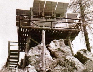
Oak Flat Lookout 1933 - 1964
Lookout Details
| Registry Numbers | US 884, OR 251 (view other lookout sites in United States, Oregon) |
| Date Registered | March 26, 2011 |
| Nominated by | Ray Kresek |
| Location |
Umpqua National Forest Douglas County, Oregon |
| Coordinates |
N 43° 17.404' W 122° 31.154' (view using Google Maps) N 43° 17' 24" W 122° 31' 09" N 43.290060° W 122.519230° |
| Elevation | 3,343 ft (1,019 m) |
| Administered by | U.S.Forest Service |
Description
Built in 1933 atop the westernmost point overlooking the mouth of Copeland Creek, this 10' pole L-5 tower was removed in 1964.
Map
Change Basemap